AI-Assisted Subsurface Intelligence & Sparse-Data Reconstruction
Celtic Sea Floating Offshore Wind – AI-Assisted Subsurface Intelligence & Sparse-Data Reconstruction
Executive Summary
This study establishes the AI-assisted subsurface intelligence layer of Morie Analytics by extending the deterministic reconstruction workflow developed in morie_soil toward a generative and reconstruction-driven geotechnical framework.
The workflow combines:
- Synthetic geological generation
- Sparse CPT-style sampling
- AI-based subsurface reconstruction
- Engineering-aware soil interpretation
- Reconstruction-quality validation
within a unified offshore engineering pipeline.
Building on the same cropped Celtic Sea domain, floating wind layout and anchor-sharing configuration used across the Morie ecosystem, the workflow introduces a new approach where AI supports the reconstruction of offshore subsurface behavior from limited investigation data.
Unlike purely statistical interpolation approaches, the methodology combines:
- GeoSyn → synthetic truth generation
- SchemaGAN → sparse-data reconstruction
- Ic-based engineering mapping → derivation of engineering soil parameters
- Validation workflows → quantitative reconstruction assessment
The result is a reproducible framework capable of transforming sparse offshore geotechnical information into engineering-ready subsurface intelligence suitable for downstream anchor and mooring workflows.
This study represents the transition from:
Deterministic soil interpolation
toward:
Engineering-aware AI reconstruction of offshore subsurface systems.
Site intelligence → Layout generation → Soil reconstruction → AI subsurface intelligence → Mooring physics → Anchor verification → Anchor prediction
Figure 1 – Integrated AI-assisted subsurface intelligence workflow linking morie_site, morie_layout and morie_soil into engineering-ready offshore reconstruction fields using SchemaGAN.
Project Scope
- Synthetic geological truth generation
- Sparse CPT-style sampling
- AI-assisted subsurface reconstruction
- Ic-based engineering parameter derivation
- Reconstruction validation against held-out truth
- Engineering-aware interpretation of reconstructed fields
- Integration with downstream anchor workflows
This study converts:
Sparse offshore geotechnical observations → engineering-ready subsurface intelligence.
Engineering Context
Early-stage floating offshore wind developments face a fundamental challenge:
How can reliable geotechnical understanding be constructed from sparse offshore investigation data?
In real projects:
- CPT campaigns are expensive
- Investigation density is limited
- Spatial variability characterization needs to adapt to floating wind needs
- Engineering decisions must often be made before full site characterization is available
In morie_soil, this problem was approached through deterministic tomographic reconstruction.
This study extends the concept further:
Generate plausible offshore geology → sparse sampling → reconstruction with AI → validation of engineering implications
The workflow does not attempt to blindly predict soil properties from coordinates. Instead, it reconstructs offshore subsurface behavior under engineering constraints while preserving geological continuity and spatial structure.
Inputs and Data Sources
This study builds directly on upstream Morie Analytics outputs.
From morie_site
- Bathymetry grids
- Soil classification context
- Cropped lease-area geometry
From morie_layout
- Floating wind layout
- Shared-anchor configurations
- Anchor coordinates
From morie_soil
- Three-layer Celtic Sea sand profile
- Cropped local domain
- Deterministic reconstruction logic
- Engineering calibration endpoints
Additional Inputs
- GeoSyn synthetic geology framework
- Sparse CPT-style sampling definitions
- SchemaGAN reconstruction architecture
- Ic-to-engineering parameter mappings
All inputs remain aligned within the same cropped Celtic Sea engineering domain used throughout the Morie ecosystem.
This provides continuity across:
- Layout definition
- Soil characterization
- Mooring analysis
- Anchor engineering
- AI-assisted reconstruction workflows
System Flow
GeoSyn Truth Generation → Sparse CPT Sampling → SchemaGAN Reconstruction → Engineering Mapping → Validation
The architecture preserves the following aspects throughout the reconstruction process:
- Geological continuity
- Engineering traceability
- Reproducibility of results
Processing Workflow
- Load cropped Celtic Sea engineering domain
- Generate synthetic geological truth fields
- Sample sparse CPT-style observations
- Build sparse reconstruction datasets
- Train SchemaGAN reconstruction model
- Reconstruct subsurface fields
- Derive engineering soil parameters
- Validate reconstruction against truth
- Export engineering-ready outputs
This converts:
Sparse offshore investigation data → reconstructed engineering fields.
Local Engineering Domain
The workflow inherits the same cropped Celtic Sea local engineering domain used in morie_soil.
This ensures continuity across:
- Bathymetry
- Soil classification
- Floating wind layout
- Anchor positions
- Downstream engineering workflows
The selected domain preserves:
- Realistic offshore scale
- Representative anchor spacing
- Layered soil behavior
- Spatial variability consistent within Morie’s portfolio
Celtic Sea Sand-State Model
The study inherits the same three-layer sand profile used in morie_soil.
Base Soil Structure Implementation
The current implementation is intentionally restricted to sand-dominated offshore environments and should not be interpreted as a complete representation of Celtic Sea geology.
The objective is to establish and validate the reconstruction workflow within a controlled geotechnical setting before extending the methodology toward clay, mixed-facies and rock environments.
| Layer | Description |
|---|---|
| 1 | Loose sand |
| 2 | Medium sand |
| 3 | Medium-dense sand |
Latent Soil-State Representation
The workflow introduces a key latent variable:
Ic — Robertson’s Soil Behaviour Type Index (Robertson, 2010)
Ic is a dimensionless CPT-derived parameter that provides a compact representation of soil behavior and can be calculated directly from cone penetration test measurements.
Following the SchemaGAN methodology, Ic is reconstructed as the primary subsurface variable because it preserves behavioral information while remaining suitable for image-based geological reconstruction.
Rather than independently reconstructing engineering parameters such as friction angle or relative density, the workflow first reconstructs the Ic field and subsequently derives engineering parameters through consistent interpretation relationships.
Engineering Parameters Derived
The reconstructed Ic field is translated into engineering-ready soil parameters including:
- Relative density (Dr)
- Friction angle (φ)
- Submerged unit weight (γ)
Engineering Significance
This approach preserves consistency while avoiding the need to independently reconstruct multiple engineering parameters between:
- Geological structure
- Soil behavior
- Engineering interpretation
The result is a reconstruction workflow that remains geotechnically interpretable while producing outputs directly usable within downstream offshore engineering analyses.
GeoSyn Synthetic Truth Generation
The workflow begins by generating synthetic offshore geological realizations using an adapted GeoSyn framework.
Figure 2 – Example synthetic offshore geological realization generated using the GeoSyn framework.
The original GeoSyn methodology is adapted from generic geotechnical environments toward:
- Offshore sand-dominated geology
- Marine depositional continuity
- Anisotropic offshore variability
- Celtic Sea layered behavior
Engineering Significance
The synthetic truth model provides:
- Controlled geological references
- Known subsurface states
- Reproducible validation targets
This enables quantitative assessment of reconstruction quality before application to real offshore investigation datasets.
Sparse CPT Sampling Framework
The synthetic truth fields are sparsely sampled using CPT-style vertical observations.
Figure 3 – Sparse CPT-style sampling used to emulate realistic offshore site investigation density.
The sampling strategy intentionally reproduces realistic offshore constraints:
- Limited investigation density from initial studies
- Large spatial gaps
- Sparse vertical observations resembling initial investigation
- Incomplete subsurface coverage
Each realization is sampled independently to produce:
- Sparse Ic observations
- Observation masks
- Reconstruction input datasets
Engineering Significance
This step reproduces one of the central challenges of offshore geotechnics:
Reconstructing reliable subsurface behavior from limited investigation campaigns.
SchemaGAN Reconstruction
The reconstruction architecture follows:
- U-Net generator
- PatchGAN discriminator
- Sparse-to-dense conditional reconstruction
What is a GAN?
A Generative Adversarial Network (GAN) is an AI architecture composed of two neural networks that learn together through competition.
- The generator attempts to reconstruct realistic subsurface fields from sparse CPT observations.
- The discriminator attempts to distinguish between reconstructed fields and known geological truth.
Through this adversarial training process, the generator progressively learns to produce reconstructions that preserve geological structure, layering continuity and spatial variability.
Unlike conventional interpolation methods, which estimate values directly between observations, GAN-based reconstruction learns the underlying patterns present within geological systems and uses them to infer geologically consistent subsurface behavior between locations.
Rather than performing simple interpolation, the model learns:
- Geological continuity
- Spatial transitions
- Offshore layering behavior
- Latent soil-state distributions
Engineering Significance
Within floating offshore wind engineering needs the workflow introduces:
- AI-assisted geological reconstruction
- Continuity-aware subsurface inference
- Engineering-consistent spatial reconstruction
Ic-to-Engineering Mapping
Once reconstructed, the Ic fields are translated into engineering-ready soil parameters.
Figure 4 – Engineering mapping from reconstructed Ic fields into engineering soil parameters.
The reconstruction pipeline derives:
- Relative density (Dr)
- Friction angle (φ)
- Effective submerged unit weight (γ’)
This translation preserves engineering consistency between:
- Geology
- Soil behavior
- Engineering interpretation
Rather than treating them as independent regression outputs.
Engineering Significance
This enables reconstructed AI fields to become directly usable by:
- Anchor sizing workflows
- Soil-structure interaction models
- Mooring analysis
- Geotechnical screening studies
Validation & Reconstruction Accuracy
A key aspect of the workflow is that reconstruction quality is validated against known synthetic truth.
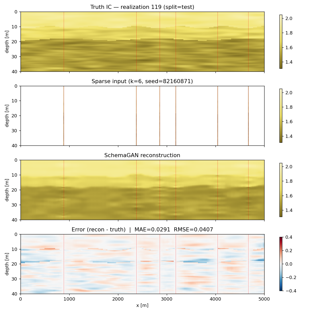
Figure 5 – Validation of reconstructed offshore subsurface fields against synthetic truth.
Validation Metrics
The workflow evaluates:
- Ic reconstruction accuracy
- Relative density reconstruction
- Friction angle reconstruction
- Unit weight reconstruction
- Boundary recovery performance
Example Results
| Metric | Mean Value |
|---|---|
| MAE (Ic) | ~0.03 |
| RMSE (Ic) | ~0.04 |
| RMSE (Dr) | ~5% |
| RMSE (φ) | ~0.4° |
| RMSE (γ’) | ~0.13 kN/m³ |
Engineering Interpretation
The results demonstrate that:
- Sparse-data reconstruction preserves engineering trends
- Reconstruction quality remains stable across held-out realizations
- Engineering parameter derivation remains physically coherent
The workflow therefore reconstructs not only geological structure, but also the engineering behavior required for downstream offshore design workflows.
While Figure 5 evaluates reconstruction quality in the latent Ic space, offshore engineering decisions ultimately depend on derived parameters such as friction angle and relative density. Figure 6 therefore evaluates whether the reconstructed Ic fields preserve the engineering behavior required for anchor and mooring design workflows.
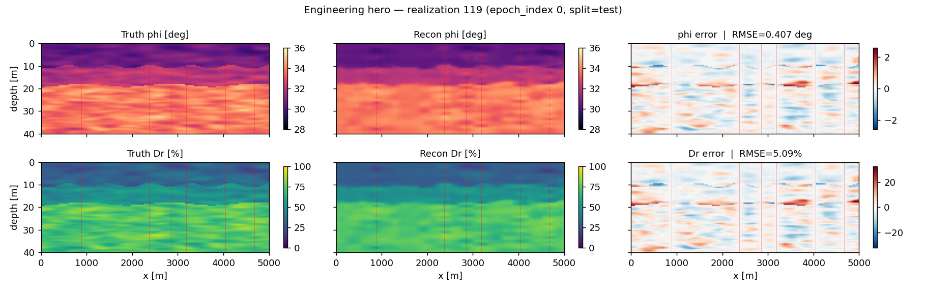
Figure 6 – Engineering-aware comparison between truth and reconstructed fields for friction angle and relative density including associated reconstruction errors.
While individual realizations help illustrate reconstruction behavior locally, offshore engineering workflows require validation across many geological scenarios. To evaluate robustness, the reconstruction metrics are aggregated across both training and validation realizations. The statistical distributions below demonstrate that reconstruction performance remains stable across unseen geological configurations while preserving engineering-consistent parameter behavior.
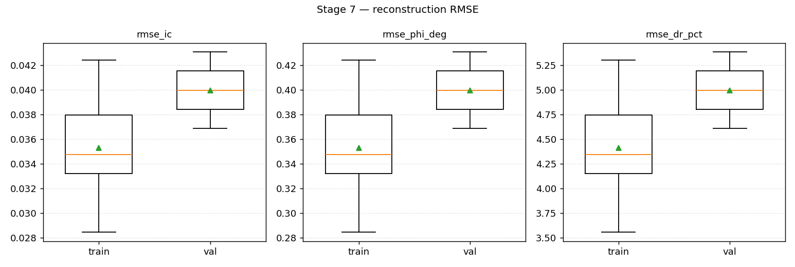
Figure 7 – Distribution of reconstruction errors across training and validation realizations for Ic, friction angle and relative density predictions.
The relatively narrow spread between training and validation distributions indicates limited overfitting within the GeoSyn-generated dataset distribution used in this study. These results should therefore be interpreted as reconstruction performance bounds within the synthetic geological domain rather than estimates of real-world reconstruction accuracy.
Validation against real offshore CPT datasets remains an important next step for future development.
Relationship with morie_sample
The adaptive CPT investigation-planning layer is intentionally separated into the following sibling study case:
morie_sample
This separation preserves architectural clarity across the Morie ecosystem.
morie_subsurface
Focuses on:
- Reconstruction quality
- Geological realism
- Engineering-aware AI fields
morie_sample
Focuses on:
- Adaptive CPT placement
- Reinforcement learning
- Investigation optimization
- Uncertainty reduction strategies
Together, the two study cases establish a unified offshore subsurface intelligence framework.
Outputs Generated
The workflow produces:
- Synthetic geological realizations
- Sparse CPT datasets
- Reconstructed subsurface fields
- Engineering parameter maps
- Validation metrics and reports
- Reconstruction comparison figures
- Engineering-ready soil fields
These outputs are directly usable in downstream offshore engineering workflows.
Engineering Applications
The outputs support:
- Early-stage geotechnical assessment
- Sparse-data interpretation workflows
- Anchor engineering studies
- Offshore uncertainty reduction
- Soil-informed mooring analysis
- Engineering-aware AI workflows
This enables:
Sparse Offshore Data → AI Reconstruction → Engineering Decisions
Relationship to Other Morie Study Cases
This study establishes the AI-driven extension of the Morie subsurface workflow.
Receives from
- morie_site → environmental context
- morie_layout → floating wind geometry
- morie_soil → deterministic soil reconstruction framework
Feeds into
- morie_sample → adaptive CPT optimization
- morie_anchor → anchor engineering
- morie_atlas → predictive anchor workflows and lease-scale visualization
It provides the transition from:
Deterministic subsurface interpretation
toward:
Engineering-aware AI reconstruction and offshore intelligence.
Why It Matters Commercially?
- Reduces uncertainty during early-stage offshore development
- Supports engineering decisions under sparse investigation conditions
- Bridges AI workflows with engineering interpretation
- Enables scalable geotechnical reconstruction workflows
- Improves integration between geology and offshore design
This is where:
- Geotechnics becomes data-driven
- Reconstruction becomes engineering-aware
- Offshore AI becomes physically interpretable
Aspects to Improve
- Validation against real offshore CPT datasets and site investigation campaigns
- Benchmarking against conventional interpolation approaches such as ordinary kriging and inverse-distance weighting
- Extension toward clay, mixed-facies and rock environments
- Native 3D reconstruction workflows
- Reconstruction uncertainty quantification and confidence mapping
- Cloud-scale reconstruction training
- Integration with adaptive CPT optimization through
morie_sample
These extensions would move the workflow toward:
Fully integrated offshore subsurface intelligence systems.
Design Philosophy
This study reflects the Morie Analytics approach:
- Physics-informed: reconstruction targets are derived from geotechnical behavior and engineering-consistent soil-state representations.
- Geology-aware: the workflow preserves offshore layering continuity and spatial depositional structure rather than performing generic interpolation.
- Mechanism-preserving: the reconstruction pipeline mirrors the sequence from sparse investigation data to engineering interpretation.
- Reproducible: synthetic truth generation, sparse sampling and reconstruction workflows are fully configuration-driven.
- Engineering-ready: reconstructed Ic fields are directly translated into parameters usable in mooring and anchor workflows.
- Site-conditioned: the framework is explicitly tied to the reconstructed Celtic Sea offshore domain and associated floating wind context.
Research Foundations
The reconstruction methodology presented in this study builds upon concepts introduced in the SchemaGAN framework developed by:
- Fabian A. Campos-Montero
- Bruno Zuada Coelho
- Evangelia Smyrniou
- Riccardo Taormina
- Philip J. Vardon
particularly regarding sparse-data subsurface reconstruction using conditional generative adversarial networks for geotechnical applications.
Within Morie Analytics, the methodology is adapted toward:
- Offshore floating wind environments
- Celtic Sea sand-state reconstruction
- Engineering-aware Ic-based parameter mapping
- Downstream anchor and mooring workflows